7 Creeks Recreation Area
7 Creeks | 7 Parks and Preserves 30+ Miles of Trails on 5,600 Connected Acres
A Natural Utopia Perfect for the Outdoors Lover
Not far off I-295, on Jacksonville’s Northside, starting at the intersection of New Berlin and Cedar Point Roads and running east to Black Hammock Island, the 7 Creeks Recreation Area offers visitors 30+ miles of trails that could occupy days of hiking, biking, horseback riding and exploring diverse ecosystems, making each mile a new adventure. This collection of parks and preserves is home to thousands of acres of unspoiled lands surrounded by expansive saltmarsh of the Timucuan Ecological and Historic Preserve that offers an extensive network of tidal creeks for kayakers, boaters, paddleboarders and anglers.

Local, State and FederalConservation Lands
The 7 Creeks Recreation Area is a compilation of 5,600 acres of contiguous conservation lands managed by local, state and federal agencies as well as non-profit organizations. The properties are managed in a collaborative effort to provide an interconnected and seamless experience for park visitors.
Presented in partnership by


Land-Based Recreation
Multi-Use Trail System
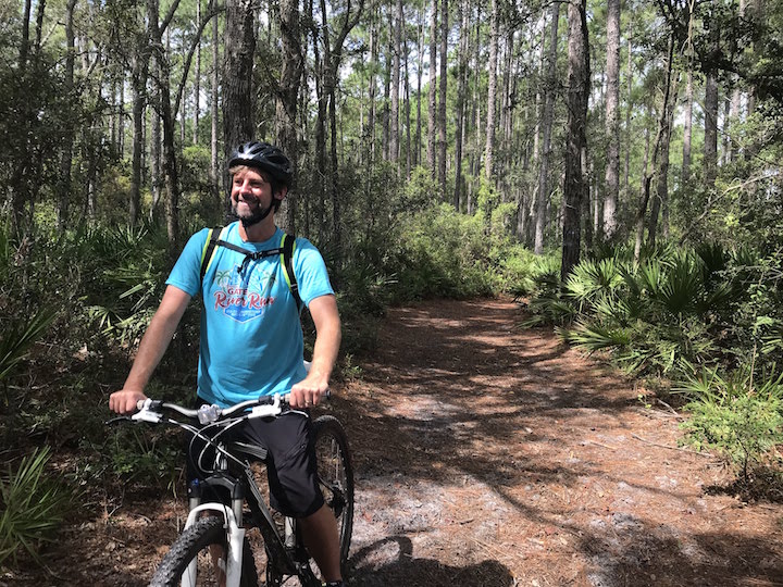
Ideal for hiking, biking or horseback riding, the 7 Creeks Recreation Area offers 30+ miles of natural-surface trails that pass seamlessly from one park to the next while winding through more than 20 diverse natural communities where you can observe native plants and abundant wildlife.
From short hikes to an all-day excursion, riverfront trails and winding pine flatwood journeys, looking to exercise or just seeking serenity—there are many types of trail experiences waiting for you.
Below are a few suggested trail options or check out the trail map and choose your own adventure. Be sure to print a copy of the trail map or simply take a photo of the trail map posted in the kiosk at each trailhead before you start on your trek. And, please abide by the following trail etiquette: hikers yield to horses & bicyclists yield to hikers and horses.
Long Distance
The 7 Creeks Trail is the best long-distance trail option that connects many facilities and exposes trail users to a variety of natural communities and scenic views. Starting from its northernmost point at the Edwards Creek Day Use Area, the trail starts you on a seven-mile journey through piney flatwoods and along saltmarsh shorelines to hardwood forest and coastal hammocks at the end at the Horseshoe Creek Trailhead. Or, start at the south end and head north. Unless you want to hike an additional 7 miles to return to your car, invite a friend and park the second vehicle at the opposite end. Or, bring a bike and lock it up at the other end to make your return trip faster.
A Shorter Hike
If you are seeking a shorter hike, select a portion of the Hammock Trail at Betz-Tiger Point Preserve, visit the historic tabby ruins at Cedar Point (NPS), or check out the loop trail at Bogey Creek Preserve.
Off-Road Cycling
Off-road cyclists tend to prefer the firm and shaded trails of Cedar Point Preserve where multiple trails loop off of the Main Trail.

Horseback Riding
For horseback riders seeking long distance options with wider trails, Pumpkin Hill Creek Preserve State Park may prove to be your favorite destination within the 7 Creeks Recreation Area. With more than 15 miles of trails that double as service roads, trail users will traverse an expansive mosaic of mesic flatwoods, sandhill and wetland ecosystem where you are likely to encounter some critters that call the park home.
Trail Etiquette
Hikers yield to horses. Bicyclists yield to hikers and horses.
Always Mind the Trail Style & Watch for Flooding
Please be mindful of the approved type of trail use as you plan your trip as some trails are designated for hiking only and a few other trails do not allow horses. Also, some trails can be occasionally flooded following rain events due to the low lying nature of the properties and may become impassable.
Picnic Facilities
Picnic areas and shelters are found throughout the 7 Creeks Recreation Area, many offering views of broad expanses of pristine saltwater marsh. Below is a list of the current picnic facilities throughout the area. Please remember to clean up after yourself so the next visitor can have an equally pleasant experience.
- Edwards Creek Day Use Area

Two picnic shelters, grill and portable toilet - Pumpkin Hill Creek Day Use Area
Picnic shelter, grill and restroom - Kayak Trailhead
Picnic tables and portable toilet - State Park Trailhead
Picnic tables and portable toilet - Bogey Creek Trailhead
Picnic tables - Cedar Point Trail Bridge
Seats on the bridge provide a great stop for lunch while on the trail - Horseshoe Creek Trailhead
Picnic tables and restroom - Black Hammock Island Trailhead
Picnic shelter, restroom and horseshoe pits
Scattered picnic tables can also be found throughout the trail system, letting you enjoy rest stops at lush cypress swamps, mossy coastal forests, or palmetto-dotted uplands.

Water-Based Recreation
Paddling and Boating
Set out to explore the extensive network of tidal creeks and salt marsh that surrounds the 7 Creeks Recreation Area with your paddleboard, kayak, canoe or boat—you will find convenient launch facilities at the following locations:
- Edwards Creek Day Use Area
Natural shoreline kayak launch on Edwards Creek - Kayak Trailhead
Natural surface kayak launch on Pumpkin Hill Creek - Cedar Point (NPS)/Horseshoe Creek Trailhead
Boat ramp on Horseshoe Creek - Bogey Creek Preserve
Kayak landing only on Clapboard Creek
Paddling Guides
The waterways surrounding the 7 Creek Recreation Area are featured in the downloadable Timucuan Trail Waterway Guide and the Nassau River-Thomas Creek Paddling Guide which you can also pick up as waterproof copies at local outdoor retailers and concessionaires such as REI, Kayak Amelia, and many others. These guides provide important information for paddlers and include suggested paddling routes.
Check the Tides
Be sure to check the tides when planning your trip as a few areas become impassable at low tide and, if heading under Cedar Point Road, it is only navigable at mid-tide due to the clearance height under the bridge.
Fishing
Head out to these fishing spots dotted along the creek shorelines—all serene locations where you can catch redfish, flounder and trout. Tight lines!
- Edwards Creek Day Use Area
Fishing platform - Pumpkin Hill Creek Day Use Area
Fishing platform - Kayak Trailhead
Natural shoreline - Pumpkin Hill Creek Overlooks
Follow the two creek overlook trails from the State Park Trailhead to find quiet shoreline fishing spots - Cedar Point (NPS)/Horseshoe Creek Trailhead
Wooden pier next to boat ramp - Cedar Point Trail Bridge
Hike in from Horseshoe Creek Trailhead, it might be worth it
Support the 7 Creeks Recreation Area
Become a friend of Timucuan Parks Foundation
The Parks and Preserves
Betz-Tiger Point Preserve
Over 500 acres of pine flatwoods and maritime hammock, surrounded by awe-inspiring broad expanses of saltwater marsh and stunning scenic views and abundant wildlife. With its adjoining neighbor, Pumpkin Hill Creek Preserve State Park, visitors can enjoy miles of nature trails for hiking, biking and equestrian use, kayak/canoe areas, and ample fishing.
Things to See and Do
Scenic Overlook | Kayak/Canoe Launch | Fishing Platforms | Hiking Trails
Biking Trails | Equestrian Trails | Picnic Shelters with Grill
Address
13990 Pumpkin Hill Road
Jacksonville, FL 32226
Location
Betz-Tiger is located at the end of Pumpkin Hill Road, past the entrance to Pumpkin Hill Creek Preserve State Park


Bogey Creek Preserve
Cypress swamps, coastal forests, and salt marsh supporting a wide variety of wildlife. Enjoy the walking trails, picnic areas, and scenic views, or land your kayaks at the landing on Bogey Creek.
Things to See and Do
Picnic Table | Kayak – Landing Only | Hiking Trails | Scenic Views
Address
5500 Cedar Point Road
Jacksonville, FL 32226
Preserve Information
For more information, visit North Florida Land Trust’s Bogey Creek Preserve page.
Cedar Point Preserve
618-acres of oak hammocks, pine flatwoods, and a freshwater marsh system that is surrounded by an intricate salt marsh ecosystem. Forested areas provide habitat for wildlife, including many wintering and migratory birds.
7.3 miles of trails available to hikers, off-road bicyclists and horseback riders as well as picnic facilities, wildlife viewing and scenic overlooks. With the completion of an impressive 245-foot trail bridge over Pumpkin Hill Creek completed in summer of 2018, the Preserve’s trail system is now connected to the National Park Service’s Cedar Point property that offers an additional 4.4 miles of hiking and biking trails at the south end of Black Hammock Island.
Things to See and Do
Picnic Tables | Scenic Overlooks | Hiking Trails | Biking Trails
Equestrian Trails
Address
Fitzpatrick Creek Trailhead - 7116 Cedar Point Road
Black Hammock Island Trailhead - 8318 Cedar Point Road


Cedar Point (NPS)
Once the site of a 16th century Spanish Mission, a 19th century plantation, and later a 20th century pine plantation. Consisting of approximately 400 acres, Cedar Point is located at the south end of Black Hammock Island.
Experience both upland hammocks and salt marsh habitats by land and water. Hiking and biking are allowed on the trails. A boat ramp provides access to some of the best fishing spots in the region. It is a popular launch site for boaters, kayakers, and paddle boarders. Birdwatchers come to Cedar Point to see over 200 species of birds, including the beautiful painted bunting.
Things to See and Do
Picnic Tables | Scenic Overlooks | Historic Sites | Kayak Launch
Fishing Pier | Hiking Trails | Biking Trails
Address
9023 Cedar Point Road
Jacksonville, FL 32226
Jim Wingate Preserve
An equestrian-themed trailhead (also welcome to hikers and bikers) that provides the only parking lot with access to the trails of Pumpkin Hill Creek Preserve State Park on the west side of Boney Road.
Things to See and Do
Equestrian Trails | Hiking Trails | Biking Trails
Address
4849 Cedar Point Road
Jacksonville, FL 32226
Preserve Information
For more information, visit the City of Jacksonville's Jim Wingate Preserve page.


Pescatello Island
Located within the Timucuan Ecological and Historic Preserve and surrounded by salt marsh, this beautiful island is completely forested and undeveloped. The island is covered by a mixture of live oaks, eastern red cedars, slash pines and saw palmetto. The uplands provide excellent habitat for a variety of songbirds and other wildlife.
Since this is an island, trail conditions on the island may vary.
To visit, please contact North Florida Land Trust at [email protected].
Things to See and Do
Birding | Kayaking
Location
Southwest of Cedar Point Preserve
Pumpkin Hill Creek Preserve State Park
Equestrians, hikers and off-road bicyclists can explore over 15 miles of multi-use trails that wind through the park’s many different natural communities and connect to the trail systems of the adjacent City preserves for even more miles of exploration. Pumpkin Hill Creek can be accessed at canoe/kayak launches or by either of the two creek overlook trails, which are perfect fishing spots.
Things to See and Do
Picnic Tables | Scenic Overlooks | Kayak Launch | Fishing |
Hiking Trails | Biking Trails | Equestrian Trails
Address
13802 Pumpkin Hill Road
Jacksonville, FL 32226
Preserve Information
For more information, visit the City of Jacksonville's Jim Wingate Preserve page.
